


MISSOULA — Citing safety concerns and a growing demand, Missoula County and a team of state partners are looking for solutions to the parking challenges at a popular recreational spot in East Missoula.
Commissioners last week met with the Montana Department of Transportation to discuss the Sha-Ron fishing access site and the flood of vehicles that often line Highway 200 once the small parking lot fills.
The location is a popular put-in among river rats who float, tube and paddle the Clark Fork River on hot summer days. It’s also popular among the college party crowd that gathers on the sandy beach.
“I’m still excited to pursue this, because the problem of people parking and walking along the road still persists,” said Missoula County Commissioner Josh Slotnick. “Our goal is to figure out how to solve that problem. I’m not too attached on how we get there, as long as we get there.”
In an effort to explore options, including expanded parking, the Montana Department of Transportation recently conducted a land survey on an adjacent easement.
The results suggested that a neighboring property owner had staked more land on the easement than what the boundary line suggests.
“They actually had more property than what MDT believes they have,” said MDT project engineer Jacquelyn Smith. “They’re saying they own to the north of that when in fact they do not. MDT has reviewed it and feels confident the line would be where (the agency) thinks it is.”
But while the boundary survey suggests there’s room to explore a parking solution, MDT doesn’t actually own the lot. Rather, it’s owned by a power company, which complicates the issue.
“That property MDT has is not actually owned by MDT,” said Smith. “We have it as an easement from the power company. Everything we’ve found is definitely not a show stopper, but there are some hurdles we have to overcome.”
One of those solutions could involve a land swap with Montana Fish, Wildlife & Parks, but even that could take time if it’s even possible. The county could manage the site in the short term and pass it on to FWP when the time is right.
However it’s resolved, the county hopes to find a solution by next summer.
“We paid a whole lot of money for someone jumping off the bridge that was ours,” said Slotnick. “I wonder if we’d end up being liable if someone got hit by a car carrying a tube on (Highway 200).”
Parking and access remains a challenge at several popular locations along the Clark Fork River, and it’s receiving attention from multiple sources. Among them, the city of Missoula plans to begin building new access sites in the urban core in an effort to shore up erosion from the many trails cut by recreators.
Last month, Missoula County also placed parking restrictions below the Interstate-90 bridge on Tamarack Road, located east of Sha-Ron in Bonner. That has forced recreators to park on Highway 200, creating a similar safety issue to what’s taking place at Sha-Ron.
“There’s multiple different agencies trying to collaborate to find solutions,” said Shane Stack, the director of Public Works for Missoula County. “MDT has an easement, so there’s no way we can do a land trade. But FWP can work with MDT and figure out a way to try and utilize that easement.”
The state opened Milltown State Park last year at the confluence of the Blackfoot and Clark Fork Rivers. The put-in offers a longer float back to downtown Missoula and includes a paved parking lot. But on hot summer days, even that lot fills up.
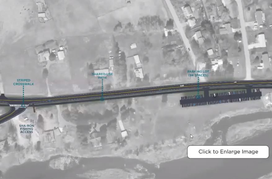
The Metropolitan Planning Organization has also included potential solutions in its Highway 200 corridor plan for East Missoula. The options include an expanded roadway and speed zone near Sha-Ron that would offer shoulder parking.
The other option would place a parking lot on an easement on Highway 200 just north of Sha-Ron. The lot would be connected to the fishing access site by a shared-use path.
“This (corridor) project is working on solutions that address overflow parking that occurs within the Highway 200 right of way,” said one project partner. “Future management of the Sha-Ron Fishing Access Site may change, but management of the site is outside the scope of this project.”
