

Powerful storms are rolling through the Midwest and are expected to spin up dangerous tornadoes later Friday.
A very serious situation is developing up and down the Mississippi River Valley; some of the energy behind these storms started out as the bomb cyclone that hit California at the start of the week.
The system dropped almost a foot of new snow in the Sierra Nevadas before moving toward the Midwest. In addition to the tornadoes, it’s also going to create blizzard conditions later Friday.
California's wet season is scheduled to end today, but the snow and rain are still falling, and in some places, they'll set new records. The UC Berkeley snow lab reports 714 inches so far.
All the snow and rain from the nonstop atmospheric rivers has pretty much wiped out the drought in California. Just 28% of the state is at minor drought levels; a year ago, it was 100%.
However, the megadrought is still firmly in place. It’s now impacting the breadbasket region, mostly from Nebraska and south through Kansas, Oklahoma and Texas.
That area of the country is under a critical wildfire threat Friday as this system pushes east.
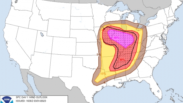
As of 10 a.m. Friday, the National Weather Service has dramatically increased the Moderate Risk zone (the red area shown on the map). While it’s called "moderate," that is misleading.
It is the 4th highest out of 5 risk threats. It now stretches from Iowa south through central Arkansas and Mississippi. There are warnings for several strong or violent long-track tornadoes.
SEE MORE: Biden deploys federal aid to tornado-wrecked Mississippi
All of this is from the bomb cyclone. As it spins, it combines with cold air and will create blizzard conditions across the Dakotas and winter storm issues through the upper Midwest.
Below the Midwest, we’ve got this system pushing east and more moisture lifting up.
All of this is going to collide right along the Mississippi and Ohio River valleys starting Friday afternoon.
That's where the severe weather alerts are coming from, and 75 million Americans are in the risk zones, according to the National Weather Service's Storm Prediction Center.
There are two bullseyes where we could see the worst of it, and those are in eastern Iowa and northwestern Illinois.
From Cedar Rapids through Springfield and from Jonesboro, Arkansas, across to Memphis and north to Paducah, Kentucky, winds will gust up to 75 miles per hour, baseball-sized hail could fall, and several strong long-track tornadoes are expected.
There is also a blizzard warning covering almost all of South Dakota that is reported to start around 4 p.m. Friday.
These powerful storms will start to roll through in the late afternoon and overnight hours. It's important that everyone have the weather alerts turned on in their phones and be severe weather ready.
Trending stories at Scrippsnews.com
