


MISSOULA — A very wet and mild weather pattern sets up this week with rounds of valley rain and mountain snow or rain/snow setting up each day through Friday.
Watch the forecast:
A few light showers on Monday morning will lead to more widespread rain on Monday afternoon and evening. The winds also pick up later today as a low pressure system works its way through the Northern Rockies.
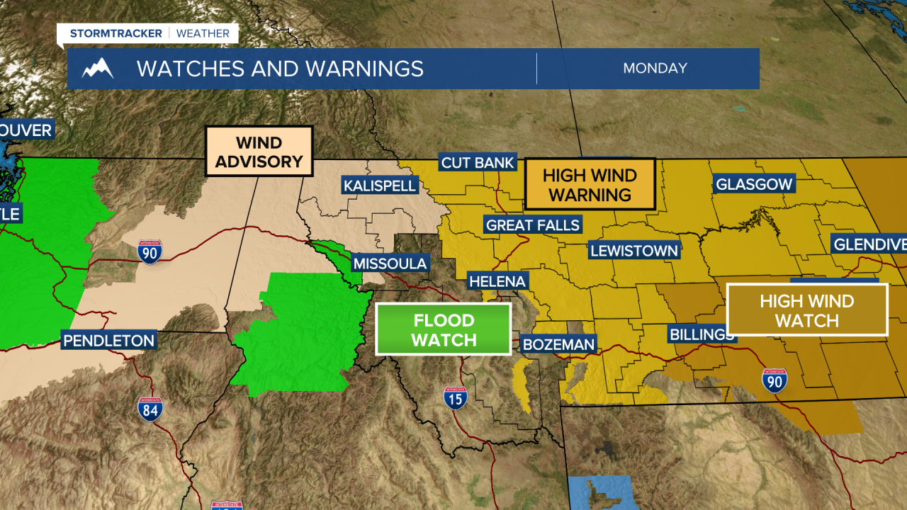
There are several watches and warnings in place today. Below is a look at the details:
- Avalanche Watch (through 4 p.m. Monday): An Avalanche Watch is in place for the mountains in northwest Montana and northern Idaho through 4 p.m. Conditions will then be evaluated at that time and could be upgraded to a warning. Heavy, wet snowfall on Monday will transition to heavy rain overnight. A potent atmospheric river will stream into North Idaho and Northwestern Montana. The rain line will rise to around 7,000 feet overnight Monday and will saturate recent snowfall and buried weak layers, and could provoke a widespread cycle of avalanches large enough to bury, injure, or kill a person. Some of these avalanches could release naturally, and it will be very easy for backcountry travelers to trigger them.
- Wind Advisory (11 p.m. Monday - 11 a.m. Tuesday): Northwest Montana west of the divide will see wind gusts of 40 mph to 50 mph tonight and continuing into Tuesday morning.
- High Wind Warning (2 p.m. Monday - 10 a.m. Tuesday): Northwest Montana east of the divide will see wind gusts of 60 mph to 70 mph tonight into Tuesday.
Rain will continue each day through Friday with rounds of heavy rain setting up for Idaho along with areas along the Montana/Idaho border.
- Flood Watch (Monday - Thursday): Clearwater and Idaho Counties in Idaho, along with Mineral County in Montana, are under a Flood Watch through Thursday. Heavy rain, along with melting sno,w could lead to a rapid rise in rivers and streams. Residents in steep terrain and near waterways should prepare for significant rises and potential flooding, as the unusual duration and intensity of this event will stress river basins far beyond typical winter norms.
Taking a quick look at the weekend, things look to dry out just a bit; however, scattered showers stick around with highs remaining in the 40s.
Watch the 24/7 StormTracker Weather stream below:
