

A strong storm system flooded roads and knocked out power with high winds in the Northeastern U.S. Tuesday night. Now, forecasters warn more heavy rain and wind could arrive in the region by Friday night.
The storm, which started Tuesday night and was moving out Wednesday, washed out roads and took down trees and power lines. Wind gusts reached 45 mph to 55 mph, and more windy weather was expected throughout Wednesday.
It followed a day of tornadoes in the South and blizzards in the Midwest and Northwest.
The storms that swept across the U.S. caused fatal accidents, including an avalanche on Wednesday in California, spawned numerous suspected tornadoes in the South and dumped more than two feet of snow in parts of the Rocky Mountains.
Some 700 flights were canceled across the U.S. on Wednesday.
SEE MORE: 1 dead, 1 injured in avalanche at California's Palisades ski resort
Authorities warned of avalanche conditions in mountainous areas of Idaho, Montana, Wyoming, Utah, Washington and Oregon on Wednesday.
A snow squall warning was in effect east of Reno, Nevada, on Wednesday evening.
Temperatures were expected to plummet across much of the West through the weekend. High temperatures may remain below freezing as far south as Oklahoma.
Forecasters warned wind chills could reach 20 degrees below zero in Chicago and Kansas City in the coming days.
Here's how the country has fared under extreme weather this week:
Northeast
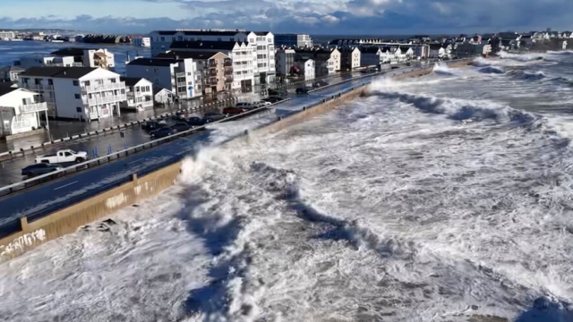
Gov. Phil Murphy declared a state of emergency in advance of the storm, many streets and roads were flooded and rivers were rising after some areas got up to 3 inches of rain since Tuesday night. The rain fell on ground saturated by another storm a few weeks ago. Another storm is forecast for the weekend.
Lou DeFazio, 65, of Manville, New Jersey, lives steps away from the Millstone River that flooded disastrously in 2021 after the remnants of Ida slammed into the state and swelled over riverbanks.
"It's getting worse and worse," he said, as the river swelled Wednesday.
Mark Nipps grew up in Manville and watched President Joe Biden's visit to the town in 2021 after flooding wrecked dozens of homes. Nipps left in large part because of the regular flooding.
"Mentally, every two years seeing your hometown devastated — that's not good at all," he said in a phone interview from his home outside Greenville, South Carolina.
Gov. Murphy said 56,000 homes were without power and several hundred accidents and highway assists were reported, but no storm deaths were reported. He said people often ignore flood warnings, to their peril.
"And we saw in the storm Ida, people pay with their lives by driving their cars into a street they shouldn't have, or staying in their home when they shouldn't have," Murphy said in an interview with CBS New York.
As high tide neared closer on Long Island on Wednesday morning, parts of the southern shore were already inundated by coastal flooding. In Nassau County, video showed cars sloshing through water that had collected on the streets of Freeport. Further east, near the Hamptons, the National Weather Service reported major flooding out of Shinnecock Bay. Several schools across Long Island said they were either canceling or delaying classes as a result of the storm.
New York City officials evacuated nearly 2,000 migrants housed at a sprawling tent complex before the storm hit amid fears that the facility could collapse in heavy winds.
Photos showed the migrant families sleeping on the floor of a Brooklyn high school, whose students were forced to go remote on Wednesday as a result of the brief relocation. The migrants returned to the tent facility at around 4:30 a.m. Wednesday after the winds had subsided, officials said.
A couple of Pennsylvania communities got more than 4 inches of rain and others received nearly that amount. Emergency responders rescued some drivers from stranded vehicles as roads flooded in low-lying areas, and downed trees and wires cut power to thousands of customers.
Forecasters said several rivers in eastern Pennsylvania saw at least moderate flooding. Another storm bringing as much as 1.5 inches of rain Friday night through Saturday would exacerbate flooding and bring very strong winds, officials said.
A dam breach in Bozrah, Connecticut, prompted mandatory evacuation orders Wednesday for several areas along the Yantic River, Norwich officials said. A power company shut down a substation along the river leaving about 5,000 homes and businesses without power.
The storm canceled events and government functions in Maine, where some areas were still recovering from a snowstorm over the weekend and flooding the previous month.
Winds gusted to 95 mph at Maine's Isle au Haut, an island in Penobscot Bay, said Jon Palmer from the National Weather Service in Gray, Maine. At the state's largest airport, high winds pushed an empty passenger aircraft into a jet bridge, Portland Jetport officials said Wednesday. No one was hurt.
In a parking lot near Widgery Wharf on Portland's waterfront, lobster fishermen attempted to turn back some of the flooding using pumps.
In Maine, Gov. Janet Mills delayed the opening of all state offices until noon Wednesday due to the storm. She encouraged residents to stay off the roads amid flash flood warnings.
"Please be sure to give plow trucks, utility crews, and emergency first responders plenty of space as they work to keep us safe," she said.
In Vermont, the storm brought wind gusts of up to 70 miles per hour and heaving wet snow, followed by rain, leaving nearly 30,000 homes without power Wednesday morning. Many schools were closed or had delayed openings.
South
On Tuesday, the same weather system brought heavy rain, hail and at least three reported tornadoes to the South before moving eastward.
Rain and high winds extended into the nation's capital Tuesday night, forcing Vice President Kamala Harris' aircraft to divert from Joint Base Andrews to Dulles International Airport near Washington when it encountered wind shear — a sudden shift in wind direction or speed.
Several deaths have been blamed on the storms. An 81-year-old woman in Alabama was killed when her mobile home was tossed from its foundation by a suspected tornado. Another person died in North Carolina after a suspected tornado struck a mobile home park. A man died south of Atlanta when a tree fell on his car.
The National Weather Service office in Tallahassee planned to send out three tornado survey teams on Wednesday to examine suspected tornado damage in Walton, Bay and Jackson counties in Florida, and two more on Thursday to look at Houston County, Alabama, and Calhoun County, Georgia.
Roofs were blown off homes, furniture, fences and debris were strewn about during the height of the storm in the South.
Many areas of Florida remained under flood watches, warnings and advisories early Wednesday amid concerns that streams and rivers were topping their banks. Gov. Ron DeSantis, who gave his State of the State address Tuesday as tornado warnings were active outside the Capitol, issued an executive order to include 49 counties in North Florida under a state of emergency.
Rescuers in Virginia pulled two people from flood waters, where they were clinging to branches after their vehicle flooded and they were then swept from its roof, according to the Albemarle County Fire Rescue. They weren't injured but were in the water for at least 10 minutes, according to spokesperson Abbey Stumpf.
Midwest
Slushy highways led to fatal collisions in Wisconsin and another in Michigan.
The storm, which began Monday, buried cities across the Midwest in snow, stranding people on highways. Some areas saw up to a foot of snow on Monday, including Kansas, eastern Nebraska and South Dakota, western Iowa, and southwestern Minnesota.
Madison, Wisconsin, was under a winter storm warning until early Wednesday, with as much as 9 inches of snow and 40 mph winds on tap.
The weather has already affected campaigning for Iowa's Jan. 15 precinct caucuses, where the snow is expected to be followed by frigid temperatures that could drift below zero degrees.
Forecasters warned snow-struck regions of the Midwest and the Great Plains that temperatures could plunge dangerously low because of wind chill, dipping to around minus 20 and even far lower in Chicago, Kansas City and some areas of Montana.
West
Storms in the Pacific Northwest and Rocky Mountains dumped snow, including 29 inches reported at Stevens Pass in Washington state and 30 inches outside of Santa Fe, New Mexico, according to the National Weather Service.
Authorities issued warnings for very dangerous avalanche conditions in mountainous areas of Idaho, Montana, Wyoming, Utah, Washington and Oregon. Backcountry travelers were advised to stay off steep slopes and away from the bottom of steep slopes.
In areas of northern Montana, temperatures could drop below minus 30 degrees by Saturday morning. High temperatures were expected to remain below freezing as far south as Oklahoma.
SEE MORE: NY school forced to go remote so migrants can be housed during storm
Trending stories at Scrippsnews.com
