

Great Falls was rattled by a small earthquake on Thursday, February 12, 2026 - the fourth one felt within two weeks.
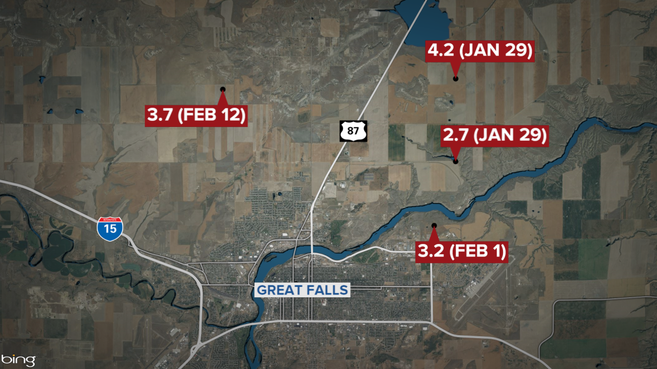
The quake happened at 6:36 p.m. The U.S. Geological Survey says it registered as a 3.7 quake.
It was centered about 5.7 miles north of Great Falls at a depth of about 6.2 miles.
People reported feeling it across Great Falls, Sun Prairie, and Ulm, and also as far away as Dutton and Choteau.
Reactions began streaming in to KRTV:
- My whole house just shook. On 10th Ave North
- Just felt a boom and the house shook, on east end of town
- Just had an earthquake in Sun Prairie
- I could feel it like crazy while I’m laying in my bed
- Felt on east end of Central Avenue
- South of Great Falls. Heard it, felt the shaking
A 4.2 quake shook the region on Thursday, January 29, 2026.
It was followed by a smaller quake of 2.7 later that evening, and then a 3.2 on Saturday, January 31 - all likely aftershocks of the first one, as was the quake this evening.
There were no injuries and no serious damage reported in any of the quakes.
The Treasure State is in one of the most seismically active regions in the United States. The intermountain seismic belt, which runs through the western third of the state, is where most of the earthquake activity occurs in Montana. The vast majority of the many quakes across the region are very small, rarely felt by people, and cause no damage. There is a team of experts at the Yellowstone Volcano Observatory who keep track of them all; click here to visit the website.
There is also an Earthquake Studies Office on the campus of Montana Tech in Butte. It operates the Montana Regional Seismic Network, a network of 42 permanent seismic stations located throughout western Montana. The website notes: "Although it has been over four decades since the last destructive earthquake in Montana, small earthquakes are common in the region, occurring at an average rate of 7-10 earthquakes per day."
The website features several interactive maps, including one that shows the 2,395 earthquakes recorded in Montana during 2018 and additional earthquakes in the surrounding region. All but 23 of those quakes registered as less than 3.0, which demonstrates how small and imperceptible the vast majority are.
There have been some notable earthquakes in Montana’s history, including the 7.3 magnitude Hebgen Lake earthquake on August 17, 1959. The earthquake triggered more than 160 new geysers throughout Yellowstone National Park. There were also around 28 fatalities from a rockslide in Madison Canyon.
And on July 6, 2017, one of the strongest earthquakes to hit Montana in decades shook the community of Lincoln northwest of Helena. It was centered 5.5 miles southeast of Lincoln at a depth of about 2.6 miles. People reported feeling the 5.8 magnitude quake across Montana and the northwest, with some reports coming from as far away as Vancouver and Lethbridge, Canada. It caused some minor damage, but no serious injuries.
The plains of central and eastern Montana are much less prone to quakes, but there have been a handful of significant ones reported.
According to the USGS, a 5.3 magnitude earthquake struck northeastern Montana on May 15th, 1909.
Several smaller quakes have been recorded in Roosevelt County, including an estimated 4.5 magnitude quake in the town of Froid that resulted in some damage to a grain bin back in 1943.
Although it has been some time since the state has seen a destructive earthquake, small quakes occur several times every day. Click here to learn more.
