


MISSOULA — After a lull in between systems on Wednesday, a multi-day weather system will impact the region starting Thursday.
Expect high impacts (heavy snow) for mountain passes and at least moderate impacts (snow to wintry mix/ice) likely in the valleys.
Watch the forecast:
While it won’t be continuous precipitation (there will be breaks from time to time), this expected potent surge of moisture is tricky to forecast, however: we currently have colder air pooling in our valleys, but incoming milder air aloft is what’s the difficult part — will we see it mix out the cold pockets quickly and allow for all rain in the valleys sooner? Or slowly mix it out, providing chances for freezing rain and mixed precipitation (likeliest scenario)?
This is what I’m seeing right now (and this is definitely evolving):
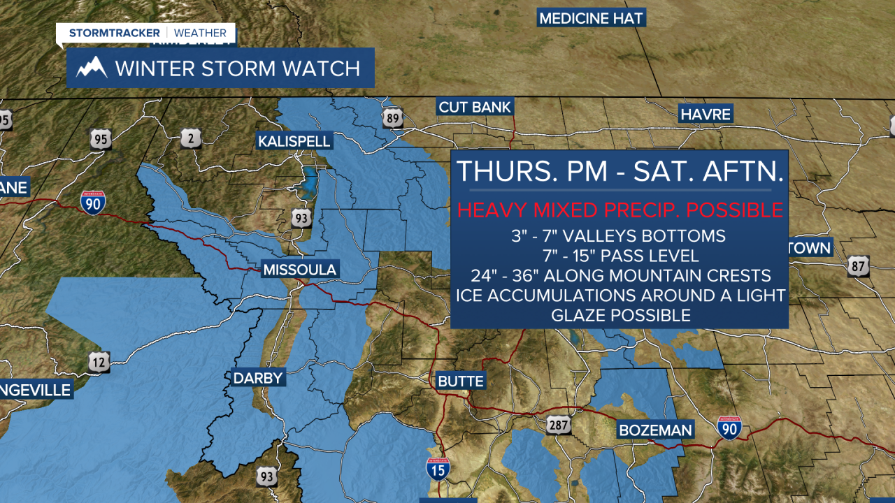
Scattered snow is most likely on Thursday and Thursday night before transitioning to a wintry mix for Friday into Saturday morning. Along and south of Highway 200/12 and I-90 (including the Mission/Missoula/Bitterroot valleys) are most likely to have the wintry mix, while portions of NW Montana (Flathead Valley) have a better chance to remain mostly snow into Friday.
Beginning Thursday, snow will impact area passes with the heaviest accumulation Friday afternoon through Saturday morning. This includes Lookout, Lolo, Lost Trail, and Marias passes.
Highs Thursday will be in the low to mid 30s, the mid to upper 30s for Friday and the upper 30s to low 40s on Saturday and Sunday. Our best bet for pockets of freezing rain in the valleys looks to be Saturday morning.
The National Weather Service Office in Missoula has issued Winter Storm Watches for various parts of Western Montana.
It looks like precipitation will lighten up a bit on Monday with only scattered mountain snow and valley rain showers and mostly cloudy skies. Highs now rise into the low 40s.
Models are indicating low to mid-40s with mountain snow and valley rain on Tuesday.
All the while, mountains will see snow — and a healthy dose at that! Expect periodic travel impacts at pass level, for certain.
It’s likely we’ll be measuring snow in FEET this weekend into early next week!
Watch the 24/7 StormTracker Weather stream below:
