


MISSOULA — Another atmospheric river has returned today and will continue through Wednesday across the region, bringing more rain (and eventually snow) and lots of wind.
A Wind Advisory is in place from 5 p.m. Monday through 3 a.m. Tuesday for the Kootenai/Cabinet & Lower Clark Fork Regions for southwest winds of 20 mph to 30 mph, with gusts up to 40 mph. A Wind Advisory is also out for the Potomac/Seeley Lake & West Glacier Regions, along with the Flathead/Mission Valleys from 7 p.m. Monday through 5 a.m. Tuesday for west to southwest winds of 15 mph to 30 mph and gusts up to 40 mph and for the Missoula/Bitterroot valleys from 11 p.m. Monday through 8 a.m. Tuesday for southwest winds of 20 mph to 30 mph with gusts approaching 50 mph.
Monday and Tuesday will feature high snow levels (generally above 6,500’-7,000’) with the widely scattered rain showers. Highs will remain above average in the 40s. We’ll see a renewed flood threat as rain falls on already saturated soils. Look for rapid rises on area waterways with rockslides possible in steep terrain. A Flash Flood Watch is in place for the Kootenai/Cabinet Region through Wednesday afternoon, where close attention is being paid to the Lower Flower Creek Diversion Structure.
A strong cold front will allow a sharp transition from rain to snow on Wednesday morning with even windier conditions. This will bring the threat of damaging winds and bursts of snow or snow squalls as snow levels drop to valley floors, along with the potential for a “flash freeze” scenario on roadways.
High Wind Watches have been issued for late Tuesday night through Wednesday afternoon as follows:
- Bitterroot/Sapphire Mountains: West 25 mph to 40 mph, with gusts up to 60 mph
- Butte/Blackfoot: West 25 mph to 40 mph, with gusts up to 60 mph
- Flathead/Mission valleys: Southwest 25 mph to 40, with gusts up to 60 mph
- Kootenai/Cabinet: Southwest 25 mph to 40 mph, with gusts up to 60 mph
- Lower Clark Fork Region: Southwest 25 mph to 40 mph with gusts up to 60 mph
- Missoula/Bitterroot valleys: West 25 mph to 40 mph, with gusts up to 60 mph
- Potomac/Seeley Lake Region: West 30 mph to 40mph, with gust up to 60 mph
Obviously, these winds will be problematic: downed trees/blocked roads and power outages are all at an elevated risk due to strong winds & wet/unfrozen ground.
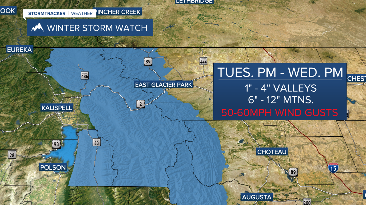
A Winter Storm Watch is also in place for the West Glacier Region from Tuesday evening through Wednesday evening, where 1”-5” are possible in the valleys and 8”-15” possible at higher elevations including Marias Pass. Winds could gust over 50 mph.
As of now, somewhat active weather looks to stay in place for Thursday & Friday with snow levels still at valley floors Thursday, but creeping back up Friday.
Watch the 24/7 StormTracker Weather stream below:
