


UPDATE: 10 p.m. - August 20, 2025
MISSOULA - The Montana Department of Natural Resources and Conservation (DNRC) reports the Corral Fire has grown to 75 acres.
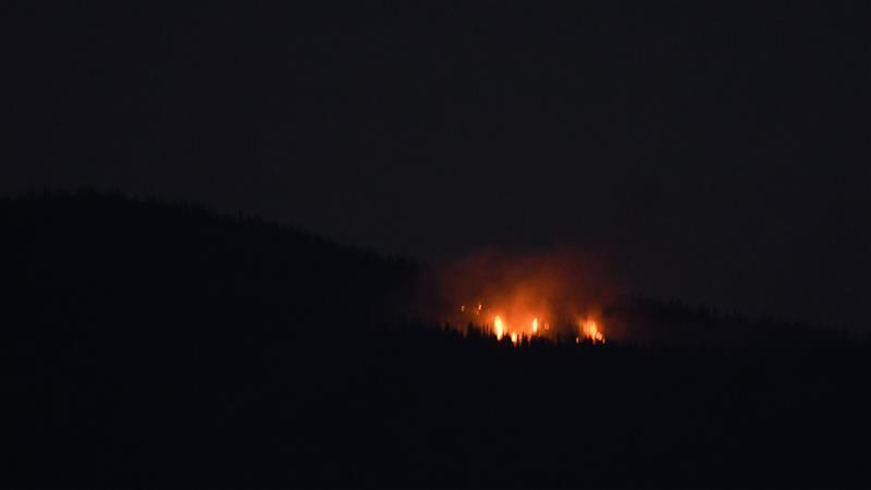
Another fire was also spotted late Wednesday night, this one north of Missoula near Snowbowl.
The DNRC is reporting the Point 6 fire is estimated at under one acre. Flames were visible on Wednesday evening.
(third report: 6:50 p.m. - Aug. 20, 2025)
The Lolo National Forest is responding to two of the four fires burning southwest of Missoula.
The Corral Creek Fire was discovered by aircraft around 4 p.m. and is burning about 4.5 miles south of Huson. It's estimated to be about 35 acres. Both ground crews and aircraft are responding. This fire was caused by lightning.
The Albert Fire was spotted around 2:30 p.m. It is also burning south of Huson and is actively being suppressed. It's estimated at 1-acre and was also sparked by lightning.
The Dog Fire located off of South Side Road, northwest of Missoula, is approximately 6 acres. The Montana Department of Natural Resources and Conservation aerial resources and engines and the Frenchtown Rural Fire District are engaged in a full suppression effort.
The Wild Horse fire remains at a half an acre.
The Lolo National Forest increased fire danger from moderate to high on Wednesday.
High fire danger means fires can start easily from many sources and will ignite quickly. Unattended fires are likely to escape and spread rapidly. Fires can quickly grow and may become difficult to control.
For information on active fire restrictions statewide, current fire incidents, and wildfire preparedness tips visit www.MTFireInfo.org.
(second report: 4:44 p.m. - Aug. 20, 2025)
A string of four wildfires is burning on Wednesday south of Mullan Road between Missoula and Frenchtown.
The largest is the Corral Creek Fire, which was spotted shortly after 4 p.m. and has grown to 35 acres.
The DNRC Interactive Fire Map shows the Dog Fire is at nearly 6 acres.
The Wild Horse Fire has burned .5 acres, and the Albert Fire, which has burned .25 acres.

(first report: 2:31 p.m. - August 20, 2025)
A wildfire west of Missoula is kicking up smoke on Wednesday afternoon.
The Dog Fire is burning in the area of mile marker 15 along Southside Road, according to the DNRC Interactive Fire Map.

The wildfire was burning approximately 6 acres as of 3:15 p.m.
Smoke can be seen from the Missoula and Frenchtown areas.
